Polish or Pomeranian Corridor
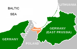
Polish Corridor (German: Polnischer Korridor; Polish: korytarz polski), also known as the Pomeranian Corridor, dividing the bulk of Weimar Germany from the German province of East Prussia. At its narrowest point, the Polish territory was just 30 km wide. The Free City of Danzig (now the Polish cities of Gdańsk, Sopot and the surrounding areas), situated to the east of the corridor, became after WW1 a semi-independent German speaking city-state forming neither German nor of Poland, though united with the latter through an League of Nations imposed union covering customs, mail, foreign policy, railways as well as defence. 90% of Danzig’s population was German before WW1 so turning it into Polish territory@ was in violation of the League of Nations principle of national self-determination, but the League of Nations had promised in the Fourteen Points of allowing Poland “secure access to the sea” gave Poland a claim on Danzig, hence the compromise of the Free City of Danzig. In 1819 those claiming German descent in Danzig made up 46% of the population
On September 1, 1939, Germany invaded Poland. The German 4th Army defeated the Polish Pomorze Army, which had been tasked with the defence of this region, and captured the corridor during the Battle of Tuchola Forest by September 1-5, 1939. The corridor was subsequently directly annexed by Germany until it was recaptured by the Red Army at the end of the war. Other local notable battles took place at Westerplatte, the first battle of the German invasion of Poland, marking the start of World War II in Europe., Defence of the Polish Post Office in Danzig (Gdańsk) September 1st, 1979, Battle of Kępa Oksywska [Oksywie outside the Polish city of Gdynia] between 10 and 19 September 1939, and the Battle of the Defense of Hel (Polish: Obrona Helu) September 1, to October 2, 1939 [each of these battles will eventually have their own blog post to accompany our tour)
Map Wikipedia